
When is a Wasteland? A Critical Understanding of Infrastructure and Residual Spaces - by Brian Rosa
Edited on
31 January 2022Urban peripheries in Europe tend to be disorderly landscapes, and the overlay of infrastructures often create areas depicted as ‘wastelands’. In this article, Brian Rosa reflects on the definition of such spaces and the uses they host. He also looks at transformation processes that aim to repurpose these residual spaces.
One thing that automobile and railway passengers have in common is that, upon entering the peripheries of cities in Europe, they are likely to come across landscapes which seem disorderly, obsolete, or without clear purpose. These places—whether sites of obsolete or existing industry, warehousing, low-income housing and informal settlements—are in fact created and sustained by the presence of urban infrastructures. Large-scale urban infrastructures such as highways, railways, and ports have long been associated with disorderly and poorly-defined landscapes on the fringes of cities: residual spaces of various scales without clearly defined purposes, often re-appropriated by a variety of formal and informal uses (light industry, warehousing, recreation, squatting, etc.).Though they seem separate from the urban fabric, they serve an essential function to cities; these are spaces that were conceived for flows of materials, people and of capital, tending to pay little mind to the impact they have at the ground level. While transportation infrastructures allow cities to exist, not everyone gains equal benefit from their dominating physical presence on urban peripheries: they have created barriers and boundaries to mobility, disproportionately impacting low-income communities.
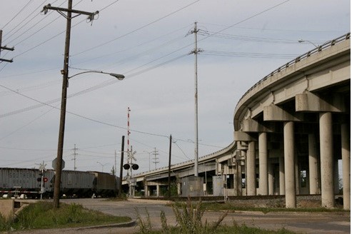
Ninth Ward in New Orleans, Louisiana. Image credit: Brian Rosa
There are many terms used to define these spaces, with one of the most common being “wasteland.” Presumably all European languages have some equivalent. In the wake of deindustrialization, expanding development pressure, and the increased desirability of waterfront properties, spaces of infrastructure on urban peripheries have become the focus of urban design, environmental remediation, and other forms of physical transformation. While these sites are often defined as under-utilized and in need of renewal; it is rare that they are fully without use, and these zones often serve as important residential, work, and recreational environments for vulnerable communities. This raises an important question: when is a site or landscape characterized as a wasteland, as opposed to simply being a blank spot on a map? In my research I have found a site becomes a depicted as a wasteland by authorities and the press at the point when it is perceived as under-productive and requiring transformation. In this sense, the use of the term “wasteland” is almost always ideological.
In recent years, we can see examples of projects around the world—especially in the Global North—that involve the dismantling and burial of urban highways and the transformation of spaces along, beneath, and above transport infrastructures as new forms of linear public spaces—so-called “infrastructural reuse.” I think we can safely argue, with examples like New York’s The High Line, that the residual spaces of elevated transport infrastructure have become the primary focus of high-profile urban design and landscape architecture projects worldwide. Often, these projects are incorporated into green infrastructure, public space, and sustainability mobility initiatives. They are often framed in terms of removing physical and symbolic barriers within cities, but are also deeply tied into the processes of stimulating property values.
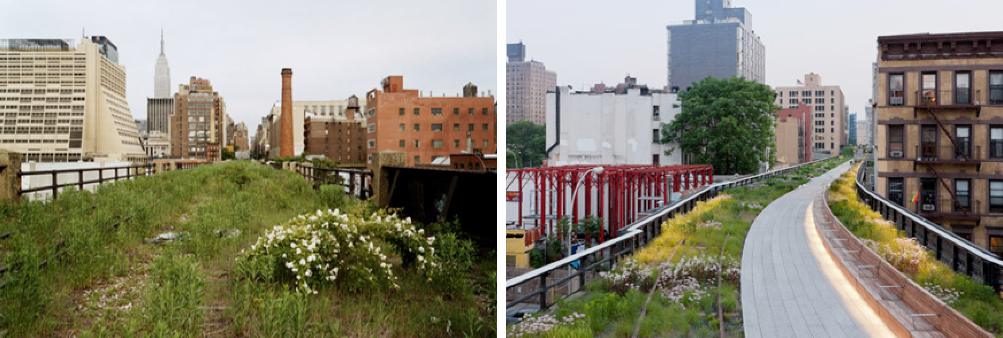
The High Line in New York City: before and after. Image credit: Joel Sternfeld, 2000 / Iwan Baan, 2011
While contexts will differ, including levels of development pressure, landownership, the relationship between the state and the private sector, and levels of public participation in decision-making processes, these transformations invariably raise political and ethical questions. These concerns are often underplayed in urban policy and planning: in cities with redevelopment pressure, the recuperation of infrastructural spaces is often explicitly associated with the economic, social, and cultural transformation of urban districts. Thus, gentrification becomes a key concern, as the previous inhabitants of “wastelands” and their surroundings are often displaced; members of the public that are able to use these spaces may not be the same people that previously occupied that locale. This is sometimes described as a process of "green gentrification," in which the sustainability-minded transformation of the urban fabric leads to the displacement of low-income communities.
Based upon these arguments, I would like to emphasize that planners and designers think about how they can work with the pre-existing characteristics of these spaces—few of which were every truly ‘empty’ or ‘wasted’—and to take proactive measures to incorporate the people who use and dwell in these spaces in their transformation. Clearly, this is not something that can be achieved by design and planning alone; it requires proactive collaboration with policy makers and community organizations to consider how improvements to environmental conditions and sustainable mobility can serve to benefit pre-existing residents and commercial activities.
 Brian Rosa is urban geographer and photographer, and Marie Skłodowska-Curie Research Fellow at the Department of Humanities, Universitat Pompeu Fabra. He is an Ad-hoc expert at RiConnect, where he supports the research of case studies and the social impact of infrastructure projects.
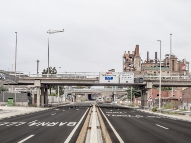
Cover image: Sant Vicenç dels Horts, Barcelona. Adrià Goula.

 Submitted by Mikel Berra-Sandín on