
The walkable city – the case of Serres
Edited on
16 August 2022The city of Serres is a typical medium-sized city of Greece, the second biggest city in the region of Central Macedonia and the capital of the regional unit of Serres. The Regional Unit of Serres is one of the seven regional units of the Region of Central Greece. Its capital is the city of Serres, with a population of 58,287 people (2011 census), namely 79.34% of the Municipality’s total population or 34.28% of the total population of the Regional Unit of Serres. More specifically, the Municipality of Serres has a permanent population of 76,817 people (2011 census).
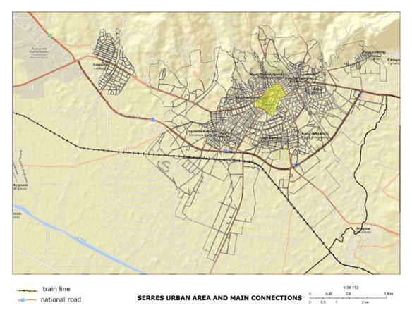
Regarding the city’s spatial structure, Serres city expands among three physical and one artificial border. The physical borders are: to the west, the St. Varvara stream, to the east the St. Georgios stream and to the north the hills of Koulas and Kallithea.
A series of projects and integrated urban reshaping interventions have been provided for and are currently implemented in the city of Serres, including multiple objectives, such as the improvement of accessibility, the promotion of non-motorized transportation, the upgrading of urban environment, the adoption of new, smart solutions and technologies, shaping a very favourable environment to bring the objectives and initiatives of the project “Space4People” to the forefront.
Challenges
The Sustainable Urban Mobility Plan SUMP Serres identified the following mobility problems in the central area of the city:
- Discontinuity of the road network
- Failure of public transportation to attract travelers away from their privately owned vehicles
- Small coverage of the alternative transportation network
- Parking problems but minimal use of public car parking stations
- Low levels of safety and comfort for pedestrians
Although the above-mentioned problems, the city, as a small-sized one keeps the characteristics of a coherent city, compact city with densified occupation and consequent overlapping of urban uses (residential, services, shopping, and recreation). The Serres SUMP study defines that almost half of the total commuting in Serres city center is on foot. This consist of a major challenge for the space4people Serres IAP vision and objectives. On the other hand, there is a great challenge to integrate the results of recent municipal projects such as expansion of pedestrian streets and bike-lane network, parking stations for communal bikes, improvement of the bus stops’ shelters etc.
Objectives
The overall vision of the Serres Space4People IAP is to support the creation of a city sustainable, resilient, inclusive, and accessible for all. Based on the major challenge of a city that is walkable, both with the various recent and planned municipal projects which will improve the public space and the active mobility within the city center, the Space4People Serres aims to support an integrated territorial planning approach closely connected with the complex nature of the city and the necessity of succeed both vertical, horizontal integration at local governmental and policy making level.
To succeed with this approach, the Serres IAP is constructed under 6 main actions of interventions as follows:
- Action A: The street as a common place for all
- Action B: Provide micro mobility and active mobility
- Action C: Parking management. From Park-and-Ride to Park-and-Walk
- Action D: Functional and aesthetic improvement of the pedestrian walking routes and stationary activities
- Action E: Regain small and remaining public spaces
- Action F: Information, promotion, and inclusion
In action
Problem analysis: Urban problems are problems of organized complexity. Thus, as a first step to tackle a challenge, it is important to make the right diagnosis by analysing the local context. For Serres problem analysis, we use URBACT toolbox especially the “problem tree” and define the emerging topics regarding the space4people theme topics. The tools helped us to have a clear problem statement, to better understand the problem itself and have a proper diagnosis of the situation.
Stakeholders’ ecosystem mapping and setting up Serres ULG: The positive experience of participatory planning during the initial phase for the preparation and analysis for SUMP, as well as the two public deliberations which took place, have shown that this is the way for bodies and citizens to express their views and to contribute to the shaping of the vision and recommendations. The planning of eight (8) meeting for the ULG of Serres, given the experience of most bodies from having participated in the SUMP process, constitutes a new, great challenge and a continuous field for deliberation and the promotion of ideas and recommendations for the improvement of accessibility and the reinforcement of safe movement on foot in the center of the city. The composition of the ULG rested on the existing stakeholder group for the Sustainable Urban Mobility Planning process and most of its members are acquainted with local, national and European policies on sustainable mobility, having participated in this process.
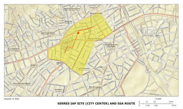
IAP site and IAP planning process: The Serres IAP site has been defined after the problem analysis, the definition of the emerging topics and the development of the logical framework. It is the wider central area of the city that concentrate central urban uses such administration, services, trade and recreation referred to a supra-local level.
The need to create a more attractive, accessible and without exclusions public space for the benefit of a city worth living in, focuses on the spaces for the movement of pedestrians, as our key priority. During the same period, the strategic planning for the city of Serres with respect to the development of mobility, which covers all modes and means of transportation, chose to follow the scenario citing the “improvement of accessibility by rendering public space to environmentally friendly means of transportation and the partial exclusion of car traffic in the city’s center”. The low dynamic of public transportation catering for citizens living in neighbouring areas and visiting the center of the city, augmented by the lack of alternative means of transportation do not allow us, at this phase, to be engaged in the development of intermodal hubs. The key objective is to improve space for pedestrians and public space, by evaluating the surface of pedestrian ways and experimenting with innovative paving and signaling solutions, aiming for the improvement of accessibility and the overall experience of the user.
The project team had always in mind to keep the IAP connected with higher level strategies (European, national and regional). Urban development leads to an increase in mobility needs, while the capacity to develop new transportation infrastructure is limited by the availability of free urban space. The European strategy on mobility promotes a new planning tool in order to manage the challenges and problems in traffic planning in urban regions in an effective, efficient and sustainable manner. This assumption originated from the planning of Serres SUMP and states the need for the redesign of our movement in cities, with the emphasis on people. This experience greatly helped in the design of actions and interventions aimed to bolster and encourage foot traffic and make the public space in Serres safer and more accessible.
Furthermore, Serres IAP is connected with detailed local strategies. The General Urban Plan adopted the recommendations put forth by the Municipality and has implemented an extensive programme of interventions to the road network of the central area, in the form of pedestrian and low traffic streets, aimed at the overall functional and aesthetic upgrading of the city center. The principle of pedestrianization and low traffic streets is also adopted for local centers. Moreover, a radial system of pedestrian – low traffic streets is proposed, connecting local centers with the city center, but also with the most important communal spaces which are located in the center or along the city’s perimeter. IAP takes account of these local strategies, as such appear in the new Operational Planning for the Municipality of Serres and for period 2020-2023 and more specifically those falling under Axis 1: “Environment and Quality of Life”. The critical issues for local development are cited there and include the “technical infrastructure and network management” and “spatial development”. The proposed interventions are aimed at upgrading the living standard and the urban environment while the indicative measures include the promotion of actions on the upgrading of technical infrastructure, smart city applications, sustainable mobility and spatial planning (source: 2020-2023 Strategic Plan).
Connecting the IAP with funding sources: The main sources of financing for the proposals to be articulated in the IAP shall be regional, national and European sources of the relevant period. The analytical inventory mapping of all Serres IAP actions and activities help us to define various funding sources per action and per project.
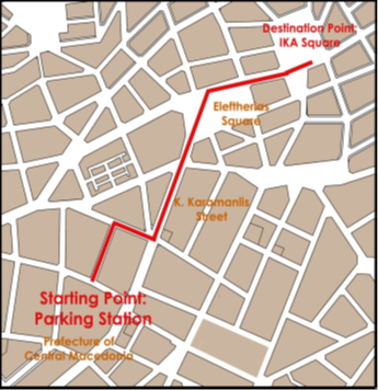
Small Scale Actions, selection procedure: The project team followed a high participatory approach to define and implement the Small Scale Action in Serres. In close collaboration with the ULG members and open surveys delivered to the citizens, the intervention site and the type of the pilot action have been decided. The SSA site selection, as part of the IAP site, was based both on the questionnaires, as well as the Baseline Study which was prepared during the initial phase of the project and the data drawn from the Urban Mobility Survey and Viable Urban Mobility Plan, which addressed and examined issues relating to mobility in the Municipality of Serres. The implementation of SSA includes the provision of two smart solar benches that will be placed in Eleftherias Square. Public benches today are a lot more than just a place to sit. Smart solar benches provide a valuable public service to people. With access to internet and device charging, could raise a level of convenience and connectivity in central urban neighborhoods, as well as a sense of safety. Furthermore, this smart urban equipment provides a marketing and information platform that delivers useful content to citizens, visitors, or passengers.
Conclusions
We can say that by finishing our participation in Space4People Network, we have equipped with knowledge, best practices, and a toolbox of solutions to implement integrated planning, resources planning, engagement and participatory methodologies and local communication actions. We will try to keep the participatory work signing a MoU between Municipality and ULG keeping it as a consulting board for watching the implementation of Serres IAP.
Lessons learnt and transferability
Serres have learned a lot by being part of space4people Network. For example, we implemented mapping and surveys inspired by our partners from Turku city, using various tools for public space analysis and diagnosis. Our main deliverable that can be useful for other same-sized Greek cities is our “knowledge and ideas book” (Greek version and adaptation to Greek context) that we are now preparing, collecting all that we’ve learned in our Space4People and URBACT journey. This book will also summarize the overall integrated planning process given step by step as a methodology roadmap for Greek planners.
Submitted by Claus Kollinger on