Nazaré
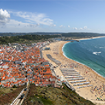
In a rather recent past, Nazaré was one of the most typical tourist postcard landscapes of the country, -with the boats, oxen, and nets laying on the beach; fishermen working on the sand or returning from the sea, and women with their traditional skirts preparing the fish to be sold in the market or to be sun-dried. Nowadays, the fishing activities moved to the port and the shore is an immense golden sandy coastline that invites tourists to rest, to sunbathe, and to practice sea and beach sports.
The Municipality of Nazaré has a large scope of competencies: mobility and infrastructures, public transport, public space, spatial planning and urban development, education, culture and heritage, healthcare, tourism, leisure and sports, youth, environment, social welfare, economic development, civil protection, etc.
Being part of the “Space4People” URBACT network will allow Nazaré to improve quantity and quality of attractive public spaces in urban areas, taking an user-centric approach by users assessing and creating future use and design of public space.
Nazaré is one of the few municipalities in Portugal with a developed Sustainable Urban Mobility Plan (SUMP), which has as its central goal improving accessibility of urban areas and providing high-quality and sustainable mobility and transport to, through and within the urban area. Nazaré`s SUMP is already in the period of implementing measures.
The partnership in “Space4People” URBACT network will improve Nazaré`s political and strategic options for the challenge of public space use for different purposes connected to transportation (driving and parking) and stay, by reassessing the current state of play in its partner cities, creating and improving capacities amongst the city partners as well as carrying out integrated planning processes carried by local planning groups to produce action plans on improving public space use in the following main areas: Pedestrian connections and (semi-) pedestrianised places; parking management and its connections to main traffic arteries; Intermodal hubs / public transport interchanges.


