
“Fringe Area of a City, Can You Show Me The Way?”
Edited on
13 April 2017Article by Enrico Formato
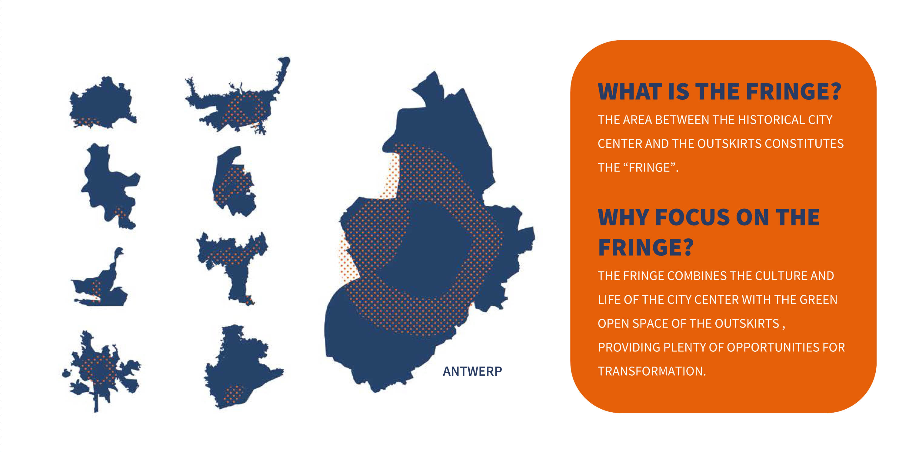
One of the most difficult challenges in our network ‘sub>urban. Reinventing the fringe’ is defining this fringe area. Where does it start and stop? What are the criteria to define a boundary? And are they the same for different target groups such as a government, the citizens, civil society, etcetera. This article’s purpose is to provide an oversight of what constitutes a fringe area in terms of geography, tools, timeframe and actors.
Where?
First, in order to define the fringe area, it’s important to determine where the fringe is situated. The fringe area is the part of the urban region where patterns of building development and non-development interweave. It has neither features of an urban compact city, nor features of a suburban village. Its features, often unprecedented, are in turn defined as: peri-urban area, urban sprawl, dispersed urban development, wide-spread city (città diffusa), territories in-between, etc. Because of the structure of contemporary urban regions (post-rounded, wide-spread, increasingly polycentric), the fringe area is not a perfect match with the surrounding area of the city.
From a quantitative point of view, several indicators can define fringe areas: some are depending on physical features (number of buildings and surface, built-up volume, parcel fragmentation, etc.); others are derived from the way in which these areas are used (e.g. housing, factories, infrastructures, …).
Landscape-reading shows territories characterised by high fragmentation, lack of urban and ecologic continuity, hybrid (not-rural, not-urban) conditions, dispersion of a sense of place caused by continuous overlapping of sectorial elements and flows. That is a non–isotropic spatial structure. It is determined by iterations, rips, spatial accumulations of scattered uses and buildings.
Seen from above, the boundaries delineating the end of the city region are not clear. The internal difference between compact neighbourhoods and fringe areas is usually highly unclear. Moreover, the dynamics of the fringes shape building settlements in a fluid manner and enable the functional mix and the local hierarchy of urban elements.
Physical boundaries rarely coincide with administrative borders (even if politicians and administrative officials occasionally presume so). In some cases, boundaries match with geographical or morphological differences (the presence of a river, mountains, the difference between historical settlements and contemporary ones, etc.). At other times, boundaries coincide with main infrastructural paths (railroads, highways, etc.), as well as with built precincts and dikes (walls, fences, etc.). Finally, internal boundaries often match with social features and functional characterisations.
How?
Secondly, how can we define what the fringe looks like? The morphology of fringe settlements is characterised by spatial fragmentation and poor quality of public space. The boundaries between private parcels and the public realm are rather strict: fences and walls are key-elements of these settlements. Moreover, fringe areas are often car-based, where people rarely meet in the streets, but rather turn to shopping malls, pubs, discos and restaurants, which act as a different kind of meeting points and common spaces than those in historic city centres. Functional and social integration, density of population and a wide range of meeting possibilities in physical public spaces are traditional values of the urban realm (in other words: traditional values of European cities); these values are not so strong in the fringes of our contemporary cities.
To face the challenge of upgrading public space both in terms of quality and use, the public administration has to push forward the question of how to enable a new ‘public space network’. This network should be able to sew up different urban parts and connect local fragments. This strategy blurs boundaries and establishes new (publicly accessible) paths in the contact zone between private plots and public streets. Some qualities are required for this new common space, namely a) topological continuity; b) efficient links with infrastructure and the urban centres; c) openness and free accessibility and d) eco-sustainable construction (permeability of surfaces, green areas and trees, rainwater recycling, etc.).
When?
Now that we have positioned the fringe and looked into what it looks like, the question rises on how we can transform this specific area over time. The construction of new public networks is defined by a long-term strategy, realised step-by-step, depending on opportunities and resources. This over-time process is needed also to improve the civil sense of inhabitance and the involvement of the citizens in the co-creation and co-managing of the widespread “public-fringe”. It is not a top-down process but it is, on the contrary, rather designed in a collaborative and community-based manner.
Who?
The final question is who can make this change happen. On the one hand, the public administration starts to operate in the publicly-owned areas, mostly on unused or abandoned land. On the other hand, new rules for private-building activity are required, in order to balance public and private interests. This process can work, for example, by claiming a part of the private-plots in private building-expansions and new-buildings constructions for public use and/or common use open to citizens. The rules should be flexible and they should each time be defined by transparent negotiations in the public arena.
AUTHOR: Enrico Formato, consultant of the local coordinator, sub>urban. Reinventing the fringe.
Submitted by isabel.michiels... on